"A new map reveals the causes of forest loss worldwide" -Science News' Laurel Hamers, Sept. 13th, 2018
Article Summary by Milana Baldizzi
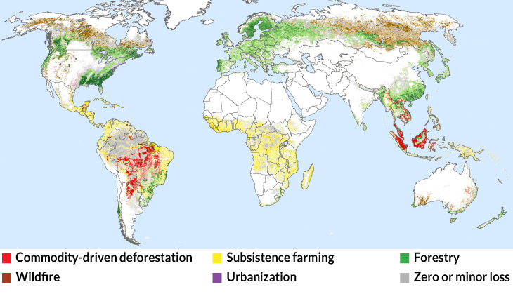
In Laurel Hamers' article, she speaks of the causes of the loss of forests and trees, and how these losses are having the ecological impacts on the environment and landscape. A recent map was released after scientists trained a computer program to analyze satellite images to determine what has been the main causes of deforestation. Researchers have discovered that in South America and Southeast Asia, the main problem was clearing trees to grow commodities such as soy and palm oil, along with subsistence farming, while in Europe and North America, tree loss is caused mostly by forestry and the usage of timber as a resource. The research can be used to determine "where and how forests are being destroyed, the data can be used to verify whether companies are sticking to commitments to protect forests while sourcing their products..." says Phillip Curtis, a consultant with the Sustainability Consortium, a nonprofit organization based in Fayetteville, Ark., and Tempe, Ariz. Also, having this analysis of data can help track carbon cycling. According to a NASA Earth Observatory article, "Carbon flows between each reservoir in an exchange called the carbon cycle, which has slow and fast components. Any change in the cycle that shifts carbon out of one reservoir puts more carbon in the other reservoirs. Changes that put carbon gases into the atmosphere result in warmer temperatures on Earth." This, along with further explanation in Laurel Hamers' article, shows that the loss of trees leads to a release of climate-warming carbon dioxide, which is normally stored in large forests. This is leading to a highly destructive warming of the planet, however, in places where trees come back, the long-term impact on the planet is reduced.